Kelantan
Darul Naim
The
Land of Culture
Overview
 Kelantan,
meaning "Land of Lightning", occupies the north-east part of the country.
It shares borders with Perak , Terengganu,
Pahang and Thailand. The State is renowned for traditional
handicrafts such as gold and silver jewellery, and traditional pastimes such
as top-spinning, puppet plays and kite-flying. The State capital is Kota Bharu.
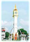
( Picture shows the City Clock Tower )
Kelantan,
meaning "Land of Lightning", occupies the north-east part of the country.
It shares borders with Perak , Terengganu,
Pahang and Thailand. The State is renowned for traditional
handicrafts such as gold and silver jewellery, and traditional pastimes such
as top-spinning, puppet plays and kite-flying. The State capital is Kota Bharu.
( Picture shows the City Clock Tower )
History
Traces of hunting and gathering
activities in rock shelters dating back to what archaeologists refer to as the
´Hoabinhian´ period have been discovered at Gua Cha and Gua Musang
in inland Kelantan. These caves were occupied by Hoabinhians between about 10,000
and 3,000 B.C. The Hoabinhian are named after cave sites in northern Vietnam.
In later times, Kelantan came under the sway of the first great power in Southeast
Asian history - the Empire of Funan. Farming methods used in Kelantan today
are believed to have their origins in Funan, as do the ever-popular ´
Wayang Kulit ´ shadow play and local weaving techniques. Kelantan was
at this time variously referred to as "Ho - Lo - Tan", "Chih
- Tu" and "Tan - Tan".
By the mid-7th Century
a new maritime power, Srivijaya, had emerged, and Kelantan soon became a vassal
of this Sumatran empire. Upon the demise of this power, it paid homage to the
Siamese, an arrangement that was to last until the emergence of the new Malacca
Sultanate in the 15th Century. With the demise of this sultanate,
Kelantan was ruled first by Johore in the 17th
Century, and later by Terengganu in the 18th
Century.
By the early 1800s, Kelantan was
easily one of the most populous and prosperous States in Malaya. This was due
to largely to the fact that, like its neighbour Terengganu, Kelantan was ´ignored´
by the concerted efforts that were being made to develop the resources found
on the west coast. Thus ignored, Kelantan went on with her own largely unimpeded
development. Kelantan did, however, maintain strong ties with Siam throughout
the 19th Century.
Kelantan lost her ´independence´
with control of the state passing to British hands following the signing of
the Anglo-Siamese Treaty Of 1909. When Japan first landed her troops upon Malayan
soil in Kelantan during World War II and the Occupation followed, control of
the state was passed to Thailand. Kelantan became a member of the Federation
of Malaya in 1948.
Geography
The State of Kelantan is located
towards the north-eastern part of Peninsula Malaysia. It is bordered by Terengganu
to the east and south-east, Pahang to the south and Perak
to the west. To the north it shares an international border with Thailand.
Kelantan has a fairly short coastline of approximately 60 kilometres, which
fronts onto the South China Sea. The State occupies a land area of 14,943 square
kilometres, and its´ capital Kota Bharu, with a population of approximately
400,000, lies to the extreme north of the State. Other towns of note in Kelantan
include Tumpat, Pasir Mas, Rantau Panjang, Bachok, Pasir Puteh, Tanah Merah
Machang, Kuala Krai and Gua Musang. Agricultural activities take up most of
the flat land of the State, with paddy-growing being the main activity in this
sector. The State is quite hilly in places, and two fairly large rivers, Sungei
Kelantan and Sungei Golok, drain the waters from the hills to the sea. Rainfall
during the months of November to December can be quite high, owing to the North-east
Monsoon which blows during this period. Temperatures range between 25 degrees
Celcius and 32 degrees Celcius, with humidity averaging 90%.
States
of Malaysia