Selangor
Darul Ehsan
Orchids
Valley
Overview
 Selangor
during its' early days, had been a 'hot-bed' of commercial and trading activities.
This led to many factional problems until the people realised that it was better
to trade than it was to fight. The State has not looked back since. It has gone
from strength to strength, and is now, without doubt, the economic powerhouse
of the country. The Multimedia Super Corridor, which partially runs through
it, will ensure that its' leadership of the country from a business and IT point
of view, will be difficult to surpass. Despite all this progress and modernisation,
the State still retains its' old charms, which can be found in the many small
towns and villages dotted throughout its' land area. These serve as a reminder
that life can be very beautiful without all the modern conveniences that Malaysians
seem to hanker after these days, in common with their counterparts living in
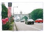
the developed countries of the world. ( Picture shows the Kota Darul Ehsan
)
Selangor
during its' early days, had been a 'hot-bed' of commercial and trading activities.
This led to many factional problems until the people realised that it was better
to trade than it was to fight. The State has not looked back since. It has gone
from strength to strength, and is now, without doubt, the economic powerhouse
of the country. The Multimedia Super Corridor, which partially runs through
it, will ensure that its' leadership of the country from a business and IT point
of view, will be difficult to surpass. Despite all this progress and modernisation,
the State still retains its' old charms, which can be found in the many small
towns and villages dotted throughout its' land area. These serve as a reminder
that life can be very beautiful without all the modern conveniences that Malaysians
seem to hanker after these days, in common with their counterparts living in
the developed countries of the world. ( Picture shows the Kota Darul Ehsan
)
History
Some Neolithic remains have
been found in the Klang Valley. Beyond that, not much is known of pre-historic
Selangor. During the 15th century, parts of modern day Selangor were under the
control of Tun Perak, the genius Bendahara of the Malacca Sultanate. Once Malacca
fell to the Portuguese though, there was a mad scramble by various parties
to assert control over the area. This was because Selangor had rich tin deposits,
which everyone wanted a share of.
 The
Dutch, after conquering the Portuguese, attempted to control the trade by building
forts at Kuala Linggi and Kuala Selangor. They were not very successful. Also,
after the fall of the Portuguese, the original Minangkabau settlers who had
hitherto drawn their support from the Malacca Sultanate, had to make way for
the more aggressive Bugis. They in their turn, successfully resisted Dutch attempts
to control them. By the middle of the 18th century, the Bugis had succeeded
in establishing the current Sultanate, with the Royal Town being Kuala Selangor.
Their influence spread as far as West Sumatra and the Riau Archipelago. (
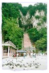
Picture shows the Batu Caves )
The
Dutch, after conquering the Portuguese, attempted to control the trade by building
forts at Kuala Linggi and Kuala Selangor. They were not very successful. Also,
after the fall of the Portuguese, the original Minangkabau settlers who had
hitherto drawn their support from the Malacca Sultanate, had to make way for
the more aggressive Bugis. They in their turn, successfully resisted Dutch attempts
to control them. By the middle of the 18th century, the Bugis had succeeded
in establishing the current Sultanate, with the Royal Town being Kuala Selangor.
Their influence spread as far as West Sumatra and the Riau Archipelago. (
Picture shows the Batu Caves )
From this point onwards the
history of Kuala Lumpur and that of Selangor
are intertwined. Increased demand for tin saw the arrival of Chinese settlers
in the 19th century, and in 1857, two Chinese tin miners, Yap Ah Loy and Chong-Chong,
went into partnership with the rival Selangor chiefs, Raja Mahdi and Tengku
Kudin, with the aim of opening tin mines in Ampang, Selangor. This gave rise
to the founding of the city of Kuala Lumpur at the confluence of the rivers
Sungai Gombak and Sungai Klang. The success of the tin miners brought about
a prolonged Civil War between the rival Malay chiefs, which ultimately involved
the Chinese tin miners, who not only fought for the rival factions, but also
fought amongst themselves. Kuala Lumpur, which until 1872 was under the control
of the Chinese Kapitan (leader appointed by the Chinese miners) Yap Ah Loy,
was razed to the ground in that year. It was, however, reconquered in 1873 by
the Malay chieftains, an act which brought an end to the wars which had been
raging thus far. The British, ever mindful of the potential wealth of the State,
decided to intervene at this point, in order to put an end to the turmoil within
the tin mining areas. In 1874 the British Governor, Sir Andrew Clarke installed
Frank Swettenham as Resident in Klang, with Sultan Abdul Samad's permission,
and the State enjoyed a period of prosperity which extended for twenty five
years. By the turn of the century, Kuala Lumpur too was a prosperous town.
In 1896, Selangor was one of
four founding members of the Federated Malay States, which were administered
by the British based at Kuala Lumpur. This grouping led to the formation of
the Federation of Malaya and independence from British rule in 1957. In 1963,
with the inclusion of Sabah and Sarawak,
the modern country of Malaysia was born.
Geography
 The
State is located on the west coast of Peninsula Malaysia, and is bordered by
the States of Perak to the north, Pahang
to the east, and Negeri Sembilan to the south. Selangor
has a coastline extending approximately 170 kilometres and has a land area of
7,956 square kilometres.
The
State is located on the west coast of Peninsula Malaysia, and is bordered by
the States of Perak to the north, Pahang
to the east, and Negeri Sembilan to the south. Selangor
has a coastline extending approximately 170 kilometres and has a land area of
7,956 square kilometres.
The capital of Selangor is Shah
Alam, which lies to the west of Kuala Lumpur, on the way to Port Klang. Amongst
the other towns in Selangor are Tanjung Malim, Kuala Kubu Baru, Rawang, Petaling
Jaya, Klang. Port Klang, Serdang, Kajang, Jennarom, Banting and Morib.
The terrain in Selangor is dominated
by the mountains of the Main Range on the east, and the flat alluvial plains
which roll on from these mountains to the sea at the Straits of Malacca. Some
of the smaller hills found in Selangorinclude Bukit Melawati, Bukit Tanjung
Keramat and Bukit Keramat Anak Dara. The hill resorts of Genting Highlands and
Fraser's Hill are shared by Pahang and Selangor.
Many rivers criss-cross the
State, the longest being the Sungai Klang. Other rivers in Selangor include
Sungai Selangor, Sungai Pangsun, Sungai Semenyih, Sungai Batangsi, Sungai Gombak,
Sungai Pusu in Gombak, and Sungai Luit in Kuala Kubu Baru.
Three of the islands found offshore
and which come under the ambit of Selangor's control are Pulau Ketam, Pulau
Lumut and Pulau Angsa.
Although the State is highly
industrialised, the main occupation and land usage are connected to the agricultural
sector.
Equatorial conditions prevail
in the State, with distinct wet and dry seasons. The months from October to
December are generally wet, with temperatures throughout the year ranging from
21 degrees Celcius to 32 degrees Celcius. Humidity, as can be expected is high,
and hovers around the 85% mark.
States
of Malaysia